Documents relating to historic boundaries for boroughs, parishes and wards can provide contextual information for archaeological sites or help locate sites of interest for further investigation.
Borough and Liberties
The area of the present Ipswich Borough, which omits part of the civil parish of Whitton, was established under the 1974 local government reforms. The boundaries were those of the former Municipal Borough established in 1835, which included both the bounds of the ancient liberties of Ipswich with the additions of parts of neighbouring parishes added to the area of the borough in 1894, 1934 and 1952 (see Youngs 1997).
Historic records dating from the thirteenth century and maps from the sixteenth century are in a single archive collection the De Saurmarez Collection (HA 93); these relate to the areas on the south eastern fringes of Ipswich including the former extra-parochial areas of Alnesbourne Priory and Half Way. The same collection also includes records for the area of Boss Hall (Bordeshowe). The areas of Whitton outside of the borough were mainly the property of the borough’s charity estate. Records in the Ipswich Borough Collection now listed on the Suffolk Archives, date from the early fourteenth century with maps from 1723 onwards.
The area of Ipswich’s ancient liberties included both the lands under the direct control of the borough and those areas outside the immediate control of the borough previously granted out as manors (e.g. Stoke by Ipswich, Wix Bishop, Wix Ufford and Brokes or Brooks) together with lands that had become the property of Ipswich’s two priories: St Peter and St Paul founded c. 1133 and Holy Trinity founded c. 1177 and other ecclesiastical estates. The boundaries of the liberty were not defined in the borough’s charters but in later perambulations dating from 1351. In 1812 the borough employed John Bransby to survey the boundaries of the liberties. The results of his work were a printed map of bounds on a scale of 2 ½ furlongs to an Inch (1:19800) of which 110 copies were printed and a published pamphlet ‘Ancient and Modern Perambulations and Extracts from Charters, Trials and Other Records relative to the liberties of Ipswich by Land and Water intended as a Companion to the Maps of those Jurisdictions’ containing a transcript of the perambulations 1351, 1522 and 1812 of which 300 copies were printed (ref. C/1/1/21 & C/1/5/4). There were further perambulations in 1672, 1695 (ref. C/3/10/1/1) and 1674 (ref. C/3/10/1/1/2). It is essential when examining sites on the fringes of Ipswich to understand where they stand in relation to the historic boundaries.
Parishes
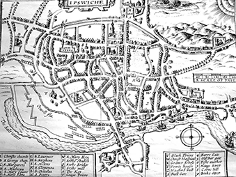
The responsibilities of the former ecclesiastical parishes for various aspects of civil administration were removed under acts of parliament in the 19th century, until their civil administration was finally abolished in 1894 and passed to the newly created civil parishes. Ipswich’s civil parishes were abolished in 1903, as was that of Rushmere St Andrew. The role of Ipswich parishes in civil administration is evident as early as 1227 when they were used as the basis for the collection of Tallage ( see Breen and Ridgard 2010). The boundaries of all of Ipswich’s parishes are first shown in colour on Monson’s 1848 map of Ipswich (ref. MC4/56). This printed map was formerly available in the record office’s map room and has now been replaced with a black and white photocopy. The boundaries are also marked on Edward White’s 1849 ‘Detailed plan of Ipswich’. White’s printed map measuring 136 cm x 121 cm was produced on scale of 60 yards to 1in (2160:1). Because of the size of this map it is not available on open access in the record office’s map room and has not been regularly used in archaeological reports. There are three copies of this map (ref. X6/11/2.1, HD 12:53/3/1 & HD 477/11).
As with the boundaries of the liberty, the boundaries of individual parishes were described in perambulations copied into Churchwardens and Overseers Account Books and Parish Books. As examples, there are perambulations records and notes of the boundaries of St Mary Tower for the year 1743 in the Overseer’s Accounts (ref. FB 91/G2/4), of the parish of St Peter’s for the years 1771, 1781, 1797, 1811, 1823 in the churchwardens accounts (ref. FB 101/E1/1), of St Mary Elms in 1764 in the churchwardens accounts (ref. FB 104/E1/4), and a separate manuscript description of the bounds of St Nicholas in 1750 (ref. FB 94/A2/1). On the same day as the churchwardens of St Nicholas set out their parish’s bounds, the churchwardens of the neighbouring parish of St Lawrence set out with hammer and chisel to record and mark the bounds of their parish. Their work is described in a written perambulation and on a sketch map of the parish included in their account book (ref. FB 106/A2/1). The description records where marks were made on buildings and the position and form of the marks. In other parishes, various points on the parishes’ boundaries were marked in the same manner and also by boundary stones or posts. The bounds of some of the Ipswich parishes were recorded on manuscript maps, such as John Bransby’s 1821 map of St Mary Elms (ref. FB104/A1/1), Robert Burcham Clamp’s plan of the parish boundaries of St Nicholas 1827 (ref. FB94/A2/6) and Horatio Ellis’ Plan of the parish of St Mary Tower 1838 (ref. FB91/A/6/2) and a Map of the parish of St Clements 1839 (ref. FB 98/A12/1). The purpose of these maps was to accurately depict the sometimes complex boundaries of the parish and detach parochial islands in order to identify those properties liable for church rates.
The positions of boundary stones and posts are recorded on the large scale 1:500 Ordnance Survey plans of 1883 and in some parishes the practice of beating the bounds continued into the 20th century. It should be noted that the perambulations and maps show the bounds of the post medieval parishes. In various medieval records there are references to the parishes of St Augustine, St George, St Mildred and St John’s Caldwell. The locations of some of these medieval churches are known but not the bounds of their parishes. The earlier Domesday parish of All Saints was absorbed into St Mathew’s, though the church itself survived until the end of the medieval period and its position is known (see Blatchly and MacCulloch 2013). Recent archaeological investigations of the site of another church known only by its geographic location as ‘Osterbolt’ has confirmed that its graveyard spans the parish boundary between St Mary Quay and St Clements showing that both parishes do not belong to the early medieval period and were established in the 12th century.
Wards
The Anglo-Saxon origin and role of Ipswich’s leets has been described by Allen (2000). The description and surviving records can be found on Suffolk Archives (ref. C/2/8). The wards or leets of the borough were defined in the Borough Black Domesday (ref. C4/1/1 f. 70). Later post medieval records grouped the parishes into the town’s ward (see Amor 2011 and ref. HA 247/42). Note that these are not the same as the wards shown on Ordnance survey maps.
Suburbs
Medieval property records contain references to property being in the suburbs of the town (see Martin 1973). This means that the property lay outside of the town’s wall and ditches. There have been a number of attempts to describe the town’s former wall and ditch and these have often been combined with speculation as to the site of Ipswich’s 12th century castle (see Wodderspoon 1850, Clegg 1984 & Wade 1981). Though the area of the town’s suburbs has not been defined, it appears to have been relatively small. The town had limited areas of waste later granted out, but no commons or common rights over open fields. The limited available space for food production may suggest that the town’s inhabitants were dependent on trade from an early date.