During the Roman period (mid 1st to early 5th centuries AD) Ipswich borough was an area of intensively populated countryside. It lay just east of the main road between the major towns at Colchester and Caistor-by-Norwich, with a minor town on this route at Coddenham. A Roman road probably also linked Felixstowe, which was another substantial settlement and a late Roman coastal fort; this road is likely to have passed through Ipswich, perhaps crossing the urban core from the south-east to north-west and from there along the Norwich Road.
Roman Settlements
Many of the Roman-period farmsteads in this area were already in existence by the first half of the 1st century (later Iron Age). The gold torcs (IPS 079) buried on high ground overlooking the Belstead Brook in the 1st century BC suggests a place of exceptional status, perhaps a religious enclosure comparable to Snettisham in north-east Norfolk. Occasional finds of Late Iron Age coins also indicate high-status activity and confirm that Ipswich fell within the territory of the Trinovantes tribe, although close to the boundary with the Iceni to the north.
Roman settlements are often located on relatively high ground overlooking the River Gipping and its tributaries. For example, at Whitehouse (IPS 247, with other findspots to the north), evidence of a timber building and ditched enclosure lay above the 35m contour, overlooking the Gipping to the west. To the north of the town an enclosure at the Albany (IPS 240) is on the 45m contour at the head of one of the small valleys that run south to the Orwell. It was inhabited between the 1st and late 3rd centuries, with activity nearby to the east probably related (IPS 047); possible further agricultural features were identified half a mile to the east at the ex-Fire Station (IPS 717). To the south of the Gipping there is a succession of potential rural settlements; at Crane Hill (IPS 185), Clover Close (IPS 030), Halifax Primary School (IPS 074) and Sheldrake Drive (IPS 082), many of them identified during 20th century building development and all minimally investigated. More recently, Roman fields, trackways and potential settlement have been identified to the south-east, on high ground overlooking the Orwell estuary to the west (IPS 390, IPS 617, IPS 676, IPS 719).
In contrast, there are areas of Roman settlement and contemporary burials on the lower ground adjacent to the river and the estuary this includes some in the Boss Hall area (IPS 867), an extensive area around Handford Road and the south end of Burlington Road (IPS 033, IPS 183, IPS 221, IPS 245, IPS 280, IPS 655, IPS 660, IPS 716). The evidence from Handford Road (mainly IPS 280) shows that there were a series of enclosures, trackways and fields from the mid-1st to the mid-3rd centuries, including probable timber buildings, a well, pottery production and iron working, with some continued activity in the 4th century, just before the establishment of an Early Saxon settlement. It is also possible that there was a Roman farmstead within the later Saxon town, with suggestive find groups around Wolsey’s College and St Mary’s church (IPS 054, IPS 055, IPS 745) and definite late Iron Age and Roman features at Elm St (IPS 053). However, many of the excavations have found Roman objects, such as tiles, that were very likely collected from elsewhere, introducing some uncertainty about how to interpret these sites. The sites at Handford Road and at Elm St are also close to the course of the Alderman Canal (River Gipping) for which a Roman origin has been suggested; and although this is highly speculative, it is not unknown for river courses to be modified, for example to provide power for a Roman water mill.
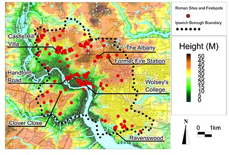
Image: All known Roman sites and findpots in the borough of Ipswich
Castle Hill Villa
The most significant Roman site in the region is the villa complex at Castle Hill (IPS 015, IPS 200, IPS 203, IPS 421 etc, sometimes also known as the Whitton villa). The villa complex has several buildings, perhaps arranged around a courtyard, located in a prominent south-facing location at 35m above OD. This is the largest known villa in Suffolk, even though we do not have a complete plan. It has all the typical Roman architectural features, including hypocausts, bath building, decorated mosaic floors and painted plaster on the walls. Most of it was examined under far from ideal conditions during the 19th and first half of the 20th century, but it seems to date from the 2nd century with considerable expansion and refurbishment during the 4th century, continuing use until the end of the Roman period in the early 5th century. It was used as a source of building material from the 6th or 7th century onwards. Unusual Roman finds from Castle Hill include a jet plaque depicting the Near Eastern deity Atys and an oculist’s stamp. It seems very possible that the Castle Hill estate took over many of the smaller farmsteads, such as Whitehouse and the Albany during the 3rd and 4th centuries. It has been suggested that the estate owner may also have had links to the administration of the late Roman military coastal defence system. Although a group of 4th century burials from an extraction pit on Dales Road (IPS 010) has been associated with the Castle Hill villa, it is likely that the owners would have had more ostentatious graves and that another cemetery is yet to be discovered.
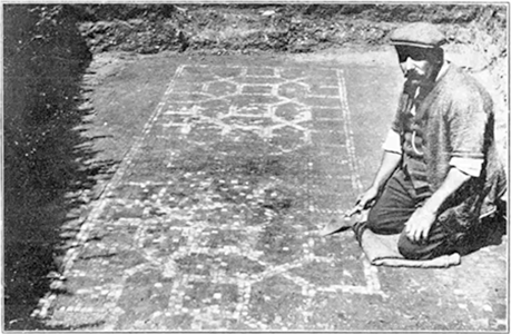
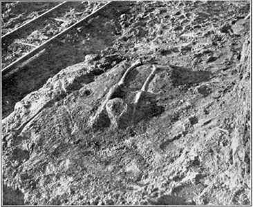
Image (left): Decorated Mosaic Pavement in red, white and black tessera discovered at Castle Hill in 1930 Image (right): and Roman cemetery with decapitated skeleton in situ on Dales Road brickfield in 1930s, both taken by Moir and Maynard