At present there is no single index of maps and plans relating to sites in Ipswich.
Suffolk Archaeological Service has scanned copies of earlier maps of Ipswich such as the work of Speed 1610, Ogilby 1674, Pennington 1778 and White 1867. The scanned copies have not been obtained from the original published maps but from photocopies of the same maps that are available in the record office’s map room at Ipswich. As the photocopies are on a reduced scale, they occasionally obscure certain details. In addition to the photocopied maps, some additional printed maps are also available on open access together with a comprehensive range of earlier editions of the Ordnance Survey maps including the 1:500 series. A primary concern of the record office which should be shared by all researchers is the long-term preservation of the records in their charge. From time to time some maps may be withdrawn for conservation or as with Edward Monson’s 1848 map replaced with photocopies.
Printed Maps
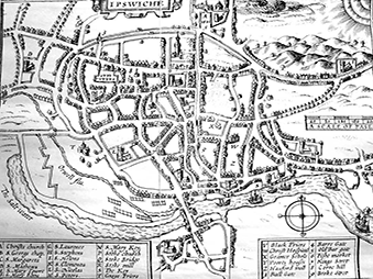
The earliest map of Ipswich is the work of John Speed (1552-1629) inset on his map of Suffolk and published in colour in his atlas ‘The Theatre of the Empire of Great Britaine’ in 1611. The book was the first to contain a full set of individual county maps of England and Wales. Most but not all of the county maps have town plans on them. The map of Ipswich has a reference table and depicts some of the town’s civic buildings, gates and quay. Unfortunately, when compared with the work of contemporary Suffolk cartographers, Speed’s map is lacking in accuracy.
John Ogilby (1600-1675) was at one time ‘His Majesty’s Cosmographer and Geographic Printer’ and is best known for publishing the first British road atlas. His 1674 map of Ipswich based on a survey by Gregory King and Robert Felgate was published on nine sheets in 1690. The map is extremely accurate except for those areas where the various sheets adjoin. The photocopies of the original map obscure an important detail in that individual buildings are shaded to show individual properties. Again there is a full table of references and Ipswich’s parish churches are carefully depicted around the borders of this map. The map also records the names of some of the landowners but not in a consistent manner.
Joseph Pennington surveyed and published a map of Ipswich in 1778, which is considered "to be executed with an extraordinary degree of correctness. At his suggestion, the names of the streets of Ipswich were first fixed" (see Clarke 1830). Pennington’s map also names various landowners, some of whom may have sponsored his work or were potential patrons. His depiction of the bounds of the River Orwell probably shows the then river at high tide. The copy of Pennington’s map marks the parish boundaries marked; this should be used with care as they may not be shown accurately on this copy (ref. MC3/3).
Edward Monson’s 1848 ‘Plan of Ipswich’ measuring 54 cm x 71 cm (ref. HD 477/10) is marked as fragile and not available for research. It has now been replaced with a black and white photocopy that obscures the coloured parish boundaries shown on the original map (ref. MC4/56).
Edward White’s 1867 map of Ipswich shows all the area within a mile’s radius of the Cornhill, Ipswich and is available on open access. His printed 1849 ‘Detailed plan of Ipswich’ on the scale 60 yards to 1 inch 2160:1, measures 136 cm x 121 cm. This map is not available on open access. There are three copies of the map (ref. X6/11/2.1, HD 12:53/3/1 & HD 477/11). This is the only map that labels public buildings to distinguish them from private houses and then employs different shading for substantial outbuildings, temporary outbuildings manufactories, shed or open buildings and conservatories. In addition to these features various properties owned by 40 named proprietors are marked with their initials and these are listed at the foot of the map.
All these maps together with the Ordnance Survey maps should be used in archaeological reports. Nearly all other maps and plans were produced for a specific administrative purpose or to further define a particular property and if used purely as a geographic representation of an area of landscape, something of their full value will be lost.
Valuation Maps
Various writers through all periods have had a tendency to reference a location in relation to a property, building or contemporary proprietor which was then well-known. Once that knowledge or memory is gone, the reader is at a loss to understand the precise location described.
The Valuation Office maps were produced in advance of the introduction of a Land Tax first proposed under the 1909 budget. The maps for Ipswich, together with the field books, are held at the National Archives. The maps for the centre of Ipswich are based on the 1:500 Ordnance Survey plans in which the boundaries of each property are coloured and are given a hereditament number. The hereditament numbers are used in the field books to identify the name of the owners and occupiers of the properties, postal addresses including house numbers and the value of each property. They also include notes on tenure and occasionally brief sketch plans of the site and observations of boundaries. As commercial directories with complete listings of each street were published 1881 onwards, once the bounds of a property is defined, its occupants can be easily traced.
These maps and books are the only complete record of the ownership in Ipswich. They are also a definitive reference as to the exact boundaries of each property. See National Archives Research Guides ‘Valuation Office survey: land value and ownership 1910-1915 and Valuation Office map finder.
Tithe Maps
All the centre of Ipswich was either free from the payment of tithes or the payment of tithes had been commuted at an earlier date. Of the 12 post medieval parishes there are tithe maps for St Mary Stoke 1841, St Clements 1844, St Helens 1844, St Mathews 1845 and St Stephens 1849. As these maps show the then rural areas of their parishes they have not been used extensively for archaeological reports. All apart from that for St Stephens are now available as photocopy.
Tithe maps should be treated with care, as they did not have to be geographically accurate being produced for the specific administrative purpose that is the conversion of tithes into a fixed rent charge. Building may or may not been shown in detail. In a number of instances the maps were either copies or enlargements of earlier maps. The maps should always be used with their apportionment which records both of the names of the owners and occupiers of the lands, fieldnames if any, cultivation and acreage. The tithe agreements set out at the start of the apportionment also have some relevance to historic geography as they sometimes account for those areas omitted from the payment of tithes. As an example of the limitations of these maps, the parish of St Margaret consisted of over 1288 acres but only 181 acres were subject to the payment of tithes (ref. FDA149/1A/1a).
Sale Plans and Particulars
To further define the boundaries of a property offered for sale, a plan of the property was inserted in the sale particulars. This practice began in the 19th century.For example, there are the sale plan and particulars for Pitt’s Farm 1811 (ref. B152/1/5/15). There are a number of copies of the plan but in this instance, they are all in a bundle of deeds and the existence of the plans is not mentioned in the catalogue. The plans do not tend to be individually listed in the archive index or catalogue.
Sale plans (especially those that predate other maps) are invaluable and even more so when care is taken to read the sale particulars. The particulars are likely to identify the previous owners and offer brief details of their right to sell the property. They will make reference to tenure whether freehold or copyhold, and for land still in agricultural use they will mention the state of cultivation of the fields. Some plans of commercial premises may contain specific details of the buildings. In some instances, antiquarian interest has meant that some maps and property plans have become detached from their original context and this does reduce their value.
Estate Maps and Property Plans
Property plans were limited before the 18th century. The earliest plan of any property in Ipswich is the ‘platte’ of Lord Curson’s house c. 1528. Copies of the original plan now held at the British Library have been published twice in the Proceedings of the Suffolk Institute (see Grimsey 1889 and Blatchly and Haward 2007). There is also a plan of the gun powder factory in Ipswich dated 1590
In 1723 Richard Tallemach was employed by Ipswich Corporation to survey various elements, but not all, of their Charity Estates (ref. C/3/10/8/1 & 11). Other maps which were a result of the same survey show the Corporation’s lands in Whitton were ascribed to Robert Wade (ref. C/3/10/8/1/4, 9 &10). Tallemach also surveyed the lands of Stoke Hall. John Castle drew Stoke Hall’s map c. 1748 (ref. HB8/5/472).
In 1735 Joshua Kirby produced a map of the Christchurch Estate which still hangs in Christchurch Mansion, but has been reproduced on a reduced scale in various publications. The surveyor Isaac Johnson mapped Stoke Hall in Ipswich in August 1792 (ref. HD11: 475/77) and in October 1805 (ref. HD11: 475/319). The references to these maps can be found in the separate catalogue of the Isaac Johnson collection, however his 1799 plans of Rope Walk are indexed in the general map catalogue only (ref. HD 1208/1,2). There is also a 1793 plan of Cold Hall Farm in St Margaret’s and St Helen’s (ref. HB1/47/2).
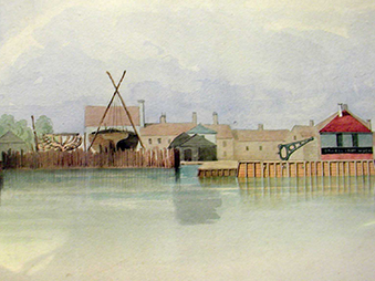
In 1791 there is the first plan of the enclosure of part of the tidal ooze to create a timber lagoon and in 1801 a new ballast quay was constructed. The plans of these developments and all the later developments of the Wet Dock and New Cut (1835-1838) are in the Ipswich Port Authority Collection (ELI). Many of the plans are the work of John Bransby (1762 -1837). Amongst the Port Authority records, Edward Caley’s 1837 sketch books of dock and dock-side buildings (ref. EL1/7/12/1,) which are presumed to be drafts for his colour plans (ref. EL1/7/12/3-6) include highly detailed drawings of a docks frontage made at low tide before the building of the Wet Dock. The books include accurate measurements and notes on the conditions of the timbers. These books have never been subjected to a detailed analysis by a timber expert. Some of the timbers may have been in place from as early as the late fifteenth century as part from the Common Quay. Each proprietor appears to have been responsible for their own quay.
Plans on Deeds
The purpose of the plans is to further define the property described in the text. The text will make a reference to the plan after the property description. The plan, and sometimes a schedule, was then entered either in a margin or at the end of the deed. Subsequent deeds may not always reuse the plan but simply refer to a plan attached to a deed of a certain date.
The quality of the plans also varies. In their simplest form, they define the property boundaries and make references to the owners of the adjoining plots. Others are highly accurate contemporary descriptions of the buildings themselves. Examples of these types of plans can be found for the Ipswich Paper Mill site later purchased by the Ipswich Water Works Company. Amongst the title deeds (ref. DD2/5/50-118) there are property plans for 1841 (107) and a detailed plan and schedule for 1851 (116). There are several plans amongst the Paul’s Deeds showing their quay site properties: One attached to a mortgage deed dated 14th November 1860 is extremely detailed and the schedule lists all the buildings on the site (ref. HC 461/1/6/2/1). The numerous plans in the deeds for the site of the former Ipswich Prison (later the site of Suffolk County Council’s Offices), St Helen’s Court were of fundamental importance for the interpretation of the site and identification of remaining structures.
Some extremely large collections of deeds have been deposited at the Suffolk Record Office. The level of cataloguing varies, with some descriptions not extending beyond the original labels of each bundle, the quantity of deeds and their date range. There has been no systematic cataloguing of those deeds containing plans of the property.
Civil Defence and Air Precautions
There are a number of annotated Ordnance Survey maps prepared for Civil Defence in advance of and at the outset of the Second World War. Towards the end of the conflict, measures were put in place to sell off both air raid shelters and defence works and to compensate the original owners of the properties. The Ipswich Borough Archives contain files relating to this process arranged by street name and often containing small plans (ref. DC 8/1/8/2-8).